

Agriculture has always been a discipline of observation. Farmers read the sky, feel the soil, watch the leaves and learn the behaviour of their land over time.
But modern agriculture now operates at a scale and pace where observation alone is no longer enough. Climate variability, water pressure, rising input costs and increasingly complex food-production systems all demand a more complete view of what is happening in the field.
The Golden Acres Project is EUCA’s response to that challenge.
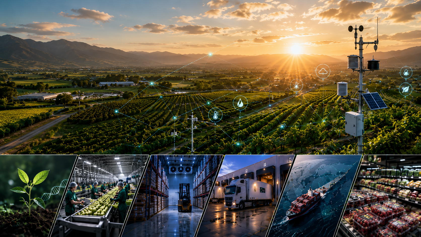
It brings together satellite remote sensing, atmospheric and soil datasets, forecast enrichment, scientific ground-truth instrumentation and AI calibration models to build virtual sensors and agricultural digital twins. The goal is not more data for the sake of data. It is better environmental understanding — at scale, and in a form that can support real decisions.

Why Agriculture Needs a Better Environmental Model
A farm is not just a piece of land. It is a living system shaped by temperature, humidity, solar radiation, wind, soil moisture, crop physiology, evapotranspiration and atmospheric demand.
These variables do not act alone. They interact constantly, shaping how crops grow, how water moves through the soil, how stress builds in the plant and how resilient a production area becomes under pressure.
In practice, many farms still rely on fragmented environmental data. A weather station may describe one point. Soil probes may describe a few depths. Satellite imagery may show spatial variation. Forecasts may indicate what could happen tomorrow. Each layer is useful, but none of them tells the full story on its own.
That gap between what is happening in the field and what decision-makers can actually see is where Golden Acres is focused.
"Satellites estimate. Ground sensors verify. AI calibration helps scale the intelligence."
The next phase of agricultural performance will not be driven by data volume alone. It will be driven by calibrated, spatially aware and operationally useful intelligence.
The Visibility Problem in Agriculture
Agriculture operates across space, but measurement often happens at only a few fixed points.
A single commercial farm may include different soil types, slopes, irrigation blocks, crop stages and management zones. One section may dry out faster than another. One canopy may begin showing stress before the rest of the field. One root-zone profile may be approaching depletion while another still has adequate reserve.
When those differences are not visible, decisions become reactive. Water may be applied where it is not most needed. Stress may only be recognised once symptoms are already visible. Resilience planning may depend more on assumption than evidence.
Golden Acres is designed to close that visibility gap by combining the scale of satellite observation with the trust of scientific field measurement and the pattern-recognition capability of machine learning.
Remote Sensing from Space
Satellite remote sensing gives agriculture a top-down view of land, vegetation and moisture dynamics at a scale that ground networks cannot easily match.
Golden Acres draws on sources such as Sentinel-2 multispectral imagery, which supports vegetation and moisture analysis through indices including NDVI, EVI, NDWI, NDRE, MSI and MSAVI2. These indices help reveal patterns in crop vigour, canopy response, water content and stress across the landscape.
Sentinel-1 radar can add further value where cloud cover or surface moisture signals are important. Wider environmental context can then be strengthened through datasets such as NASA POWER, satellite-derived evapotranspiration products, SMAP soil moisture products and SoilGrids soil-property layers.
Remote sensing is powerful because it shows variation. It can show where a field is behaving differently, where vegetation response is weakening or where moisture-related patterns are emerging.
But satellite signals are still indirect. They need to be interpreted, calibrated and checked against measured reality.
"Remote sensing gives scale. Ground truth gives trust."

Why Ground Truth Matters
The ground-truth layer is what makes Golden Acres scientifically serious.
Satellite systems can show patterns from above, but field instrumentation helps confirm what those patterns actually mean on the ground. It allows the model to learn from measured reality instead of relying only on estimation.
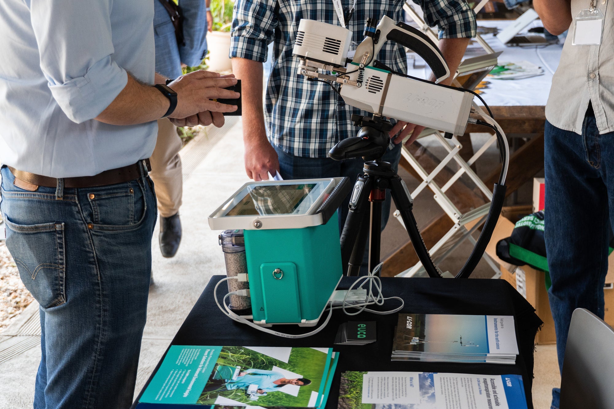
Ground-truth instrumentation may include LI-COR evapotranspiration and flux systems, carbon flux equipment, trace gas monitoring, PAR sensors, soil moisture probes, soil temperature probes, weather stations and edge IoT telemetry.
LI-COR eddy-covariance systems are especially important because they support direct measurement of evapotranspiration and exchange processes between the land surface and the atmosphere. In practical terms, that means the system can begin to compare what models suggest against what the crop and environment are actually doing.
This matters when trying to understand whether crops are losing water faster than expected, whether atmospheric demand is turning into measurable stress, or whether soil conditions below the surface are changing before the canopy visibly responds.
Environmental Physics, Not Just Weather
Agriculture does not only need weather data. It needs environmental physics.
Temperature, rainfall and relative humidity are useful, but they are only part of the picture. The relationships between variables are often where the real intelligence sits.
- Vapour Pressure Deficit (VPD) describes how strongly the atmosphere is pulling moisture from crops and surfaces. High VPD can drive rapid water loss even when soil moisture appears adequate.
- Evapotranspiration (ET) describes the combined movement of water from the land surface and vegetation into the atmosphere which is a critical variable for irrigation scheduling and water-demand estimation.
- Solar radiation, wind speed and atmospheric pressure shape the energy balance of the crop surface, influencing both photosynthesis and water loss.
- Surface wetness, root-zone moisture, soil profile moisture and soil temperature describe different layers of the water system, each relevant to different aspects of crop performance and stress response.
Agriculture does not need more disconnected data points. It needs a more complete environmental model.
Golden Acres is built to connect these layers into a more complete operating model of the field: what water is present, what water is available, how quickly it may be lost and what the crop is likely to experience next.
AI Calibration and Virtual Sensors
Artificial intelligence becomes useful in agriculture when it is grounded in measurement.
Golden Acres uses machine-learning methods to learn the relationships between satellite signals, atmospheric conditions, soil behaviour, forecast patterns and measured ground data. That calibration layer is what makes virtual sensing possible.
The principle is straightforward. Physical sensors provide trusted observations at specific points. Satellites provide spatial coverage across the landscape. Forecasts add forward-looking context. AI calibration connects these layers so that likely environmental conditions can be estimated beyond the exact locations where instruments are installed.
"AI is not replacing measurement. It is extending measurement."
Virtual sensing does not remove the need for hardware. It extends the value of a well-placed instrumentation network by allowing physical measurements to support broader environmental visibility across blocks, zones or larger production areas.
This is especially valuable where dense sensor deployment would be too expensive, slow or impractical.
Agricultural Digital Twins
In agriculture, that means more than a map or dashboard. A useful agricultural digital twin should describe the evolving state of crop condition, soil water, atmospheric demand, radiation, forecast risk and likely stress response as new data becomes available.
Golden Acres is being developed to support that kind of model. In practical terms, the digital twin may include virtual weather stations, virtual soil probes, crop stress prediction, evapotranspiration modelling, irrigation intelligence, block-level comparison and confidence scoring based on calibration quality.
This is where the system moves from observation toward decision support.
Farmers, irrigation teams and research groups do not only need to know what happened yesterday. They need to understand what is happening now, what is likely to happen next and where action may prevent avoidable stress or inefficiency.
Real-World Example: Responding to a Forecast Heatwave
Consider a food crop moving toward a forecast heatwave.
Atmospheric models show rising temperatures and increasing VPD over the next forty-eight to seventy-two hours. Satellite imagery begins to show weakening vegetation response in one section of the field. Soil-moisture modelling suggests root-zone depletion may occur within forty-eight hours if conditions continue. Ground instrumentation confirms that evapotranspiration is already increasing.
When these signals are combined, the digital twin can help identify which production zones are most exposed, estimate how quickly stress may progress and indicate where irrigation intervention may be needed first.
Instead of waiting for visible crop stress, the operator gains a chance to respond earlier and with better context.

"Predictive environmental intelligence allows action before visible crop stress becomes severe."
This is the practical value of Golden Acres: not simply knowing what is happening now, but understanding what is likely to happen next.
Research and Commercial Applications
Golden Acres is designed to bridge two worlds that are often treated separately: research-grade environmental science and operational agriculture.
For research teams, the platform can support carbon flux measurement, trace gas monitoring, irrigation science, crop modelling, remote-sensing validation and climate adaptation studies.
For commercial agriculture, the same architecture can support irrigation scheduling, water allocation, heat-stress response, crop-condition monitoring, yield resilience and operational decision support.
This dual relevance is intentional. Research rigour improves commercial reliability. Commercial deployment generates the long-term datasets that make research more useful and robust.

The same architecture can support research discovery and commercial decision-making.
Golden Acres Inside the Earth Project Vision
Golden Acres should be understood as the agricultural starting point of a broader environmental intelligence vision: the Earth Project.
Agriculture is the right place to begin because farms sit at one of the most measurable intersections in the real world: atmosphere, water, soil, carbon, energy and food.
If that interface can be modelled more effectively, the same intelligence architecture can eventually extend into wider land, water, atmosphere and ecosystem monitoring.
"Golden Acres is the agricultural starting point. Earth Project is the larger environmental intelligence vision."
The Future of Agricultural Intelligence
The future of agriculture will not be defined by one satellite, one sensor, one forecast model or one algorithm.
It will be defined by the fusion of these layers into trusted environmental intelligence: measured where possible, modelled where necessary and calibrated continuously against reality.
Golden Acres is being built with that future in mind. It is a long-term project grounded in scientific measurement, designed for practical use and open to collaboration with the research and agricultural communities that share this vision.
EUCA is actively exploring research partnerships, pilot deployments and strategic collaborations around the Golden Acres Project. If you are working in agricultural research, commercial food production, irrigation science, climate adaptation, carbon and trace gas monitoring, food-security planning or environmental resilience, we would welcome the opportunity to connect.
Get in touch with the EUCA team to explore how Golden Acres can support your work.